InRadiant Earth InsightsbyRadiant EarthInterview with Kyle Barron on GeoArrow and GeoParquet, and the Future of Geospatial Data AnalysisYou’ve spent years figuring out how to visualize large geospatial datasets in web browsers. Can you tell us a bit about your background and…Dec 11, 20241Dec 11, 20241
InRadiant Earth InsightsbyRadiant EarthEmbracing Geospatial as a Primary Data Type: A Call to Action for the Data CommunityBy Chris Holmes, Radiant Earth Technology Fellow at Radiant Earth, and Javier de la Torre, Founder and Chief Strategy Officer at CARTOJul 18, 20242Jul 18, 20242
InTDS ArchivebyAbdishakurLand use/Land cover classification with Deep LearningIdentifying the physical aspect of the earth’s surface (Land cover) as well as how we exploit the land (Land use) is a challenging problem…Aug 24, 20189Aug 24, 20189
InCode Like A GirlbyPetrica LeucaPlot(ly)ing Geo Data From DuckDBHow to analyze and plot geospatial data with DuckDB and PlotlyFeb 19, 2024Feb 19, 2024
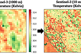
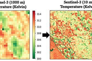
InTDS ArchivebyMahyar Aboutalebi, Ph.D. 🎓Downscaling a Satellite Thermal Image from 1000 m to 10 m (Python)Thermal Sharpening of Sentinel-3 Images: From 1 Km to 10 m Using Python in Google ColabMar 6, 20244Mar 6, 20244
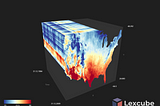
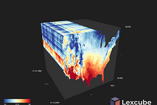
InTDS ArchivebyMahyar Aboutalebi, Ph.D. 🎓3D Visualization of Geospatial Big Data by Lexcube! (Python)Learn how to work with Lexcube, a Python package for data visualization in the space-time domain!Feb 12, 20242Feb 12, 20242
InTowards AIbyJohn Loewen, PhDGeoGPT+ Tutorial: Web-Ready Map Visuals From GIS Forest Fire DataStep-by-step guide on using the GPT-4 GeoGPT+ plug-inFeb 16, 20244Feb 16, 20244
InUrban AIbyUrban AIThe Power of Generative AI in Urban Planning: Text2Map RevolutionIn the last 3–5 years, the rapid development of artificial intelligence has unveiled radically new possibilities across many industries…Oct 4, 20232Oct 4, 20232